Map of Life
![]() The Map of Life is a collaborative academic effort to help mobilize and bring together different species distribution data types and sources, providing model-based integration and a system for the community to build upon this knowledge. The goal is a knowledge base and platform for species distribution map development, along with a set of tools for querying, accessing, improving and analyzing data. Map of Life is funded by NSF, NASA and other sources, endorsed by the GEO Biodiversity Observation Network, and is guided by an international Steering Committee of leaders in spatial biodiversity science and conservation.
The Map of Life is a collaborative academic effort to help mobilize and bring together different species distribution data types and sources, providing model-based integration and a system for the community to build upon this knowledge. The goal is a knowledge base and platform for species distribution map development, along with a set of tools for querying, accessing, improving and analyzing data. Map of Life is funded by NSF, NASA and other sources, endorsed by the GEO Biodiversity Observation Network, and is guided by an international Steering Committee of leaders in spatial biodiversity science and conservation.
ICARUS Initiative
![]() The goal of the ICARUS (International Cooperation for Animal Research Using Space) Initiative is to observe global migratory movements of small animals through a satellite system. To date scientists are unable to follow small animals and insects on their long journey. To remedy the worldwide lack of knowledge about the distribution and the individual migratory habits of small animals and insects, an international consortium of scientists got the ICARUS project underway in 2002. The project which was rated excellent in the ELIPS program of the European Space Agency (ESA) by the European Science Foundation in 2009 is funded by DLR aerospace management since 2012 as a scientific project in the framework of the “National aerospace program space station and manned spaceflight” and also supported with great commitment from the Russian Aerospace agency ROSCOSMOS.
The goal of the ICARUS (International Cooperation for Animal Research Using Space) Initiative is to observe global migratory movements of small animals through a satellite system. To date scientists are unable to follow small animals and insects on their long journey. To remedy the worldwide lack of knowledge about the distribution and the individual migratory habits of small animals and insects, an international consortium of scientists got the ICARUS project underway in 2002. The project which was rated excellent in the ELIPS program of the European Space Agency (ESA) by the European Science Foundation in 2009 is funded by DLR aerospace management since 2012 as a scientific project in the framework of the “National aerospace program space station and manned spaceflight” and also supported with great commitment from the Russian Aerospace agency ROSCOSMOS.
Movebank
![]() Movebank is a free online tool created to help researchers manage, share, analyze and archive animal movement data. The Movebank project is hosted by the Max Planck Institute for Ornithology in coordination with the North Carolina Museum of Natural Sciences, the Ohio State University and the University of Konstanz. Movebank collaborates with numerous governmental agencies, universities and conservation organizations, and has received funding from the National Science Foundation, the German Aerospace Center, the German Science Foundation and NASA.
Movebank is a free online tool created to help researchers manage, share, analyze and archive animal movement data. The Movebank project is hosted by the Max Planck Institute for Ornithology in coordination with the North Carolina Museum of Natural Sciences, the Ohio State University and the University of Konstanz. Movebank collaborates with numerous governmental agencies, universities and conservation organizations, and has received funding from the National Science Foundation, the German Aerospace Center, the German Science Foundation and NASA.
Global Environmental Layers (EarthEnv)
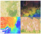 The EarthEnv project is a collaborative project of biodiversity scientists and remote sensing experts to develop near-global standardized, 1km resolution layers for monitoring and modeling biodiversity, ecosystems, and climate. The climate layers include remotely sensed data to assist in the interpolation of weather station data across the globe. The land cover layers integrate several independent land cover products derived from diverse remotely sensed data and provide accuracy-weighted consensus land cover information on a continuous scale. In addition, high resolution Landsat images are used to quantify spatial heterogeneity of land cover and characterize its changes over time. High quality, high resolution, environmental data is crucial to understand the environmental controls on biodiversity and the potential impact of global change. See earthenv.org to explore the growing list of available datasets including the 1-km Consensus Land Cover map (Tuanmu & Jetz 2014), cloud cover climatology (Wilson & Jetz 2016), and freshwater environmental variables (Domisch et al. 2015). The funding for this project comes from NASA, NCEAS, and iPlant.
STOAT
 The Spatiotemporal Observation Annotation Tool (STOAT) is a cloud-based environmental annotation platform that addresses these limitations to provide flexible and large-scale biodiversity-environment annotation services. Developed with support from NASA, STOAT is optimized for large biodiversity datasets and allows user-specified spatial and temporal grains (buffers) in support of environmental characterizations that account for the uncertainty and scale of data and of relevant processes. The tool includes a growing set of high-resolution remote sensing data from Earth-orbiting sensors (including LANDSAT, MODIS, CHELSA, and others) at native resolution and provides user-friendly tools for annotation task management and result. STOAT conducts all annotations in the cloud, obviating the need for users to download and manage complex and computationally expensive remote sensing resources. STOAT lowers technical barriers of entry for the use of remote sensing layers, and enables versatile and scalable annotations beyond those previously available in comparable tools. STOAT is available at mol.org/stoat , and is also implemented as a R package (rstoat) for programmatic access.